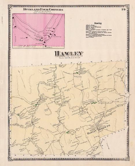
These 12 Town of Hawley Tax Maps were developed and updated by Tighe and Bond as part of a Geographic Information Systems (GIS) project contracted with them by the Commonwealth of Massachusetts.
The maps show individual parcels, easements, tie lines, lot numbers, dimensions and sizes, “911” addresses, historic lines, conservation lines, trails and wetlands.
In addition to the twelve maps, an Index is provided which can be used to determine the spatial relationships between the maps. The 12 maps are current as of 2020. Also included below is a supplemental web facility which uses a variety of mapping sources in an interactive format. For access and an explanation, go to Other GIS Maps.
If you have questions about the maps, contact Virginia Gabert at Treasurer@townofhawley.com.
Tax Map Index
The index is a rectangular grid broken into 12 sections defining each of the 12 maps. For purposes of orientation, a few features are displayed on each map section of the index.
Tax Map #1
Far NW corner of Town, showing only a few parcels. Bounded by Charlemont on the North and Savoy on the West. Notable Road: West Hawley.
Tax Map #2
North Central section of Town, bounded on the North by Charlemont. Notable Roads: Sears and Bozrah.
Tax Map #3
Far NE corner of Town, bounded on the North by Charlemont and on the East by Buckland. Notable Roads: Energy Lane and Dodge Corners.
Tax Map #4
Upper-West-central section of Hawley, bounded on the West by Savoy. Notable Roads: West Hawley, Forge Hill and West Hill.
Tax Map #5
Upper-central section of Hawley, bounded on the East by Map #4. Notable roads: Forge Hollow, Pudding Hollow, Middle and a section of East Hawley Road.
Tax Map #6
Upper-East-central section of Hawley, bounded on the East by Buckland. Notable roads: Forget, East, Pond, LaBelle.
Tax Map #7
Lower-West-mid-central section of Hawley, bounded on the East by Savoy. Notable roads: Savoy and West Hill.
Tax Map #8
Lower mid-central section of Hawley, containing significant State Forest lands. Notable roads: Moody Spring, Sprague, Hallockville, Hunt and Penobscot.
Tax Map #9
Lower-East-mid-central section of Hawley, bounded on the East by Buckland and Ashfield. Notable roads: Plainfield, Ashfield, Buckland and Clark.
Tax Map #10
Lower SW section of Hawley, bounded on the West by Savoy and on the South by Plainfield. Notable road: Stetson.
Tax Map #11
Lower Central section of Hawley, bounded on the South by Plainfield. Notable roads: King’s Corner, South and Hell’s Kitchen.
Tax Map #12
Lower SE section of Hawley, bounded on the East by Ashfield and on the South by Plainfield. Notable roads: South and Watson.
Other GIS Maps
In addition to the static tax maps shown above, try the Massachusetts Interactive Property Mapper. This one includes map overlays, town, lot and county lines, elevations and other features which can be combined on a map and can be accessed via your web browser.